
 (password required)
2019 HFIP Demonstration | Tracker and Diagnostic Files
- About
- Tracker
- Diagnostic
- Global IDs
- Reg IDs
- Consensus IDs
Modeling groups participating in the 2019 HFIP Demonstration System deliver Tracker and Diagnostic files to the Tropical Cyclone Modeling Team (TCMT) at NCAR. The TCMT makes these data available for download to the larger HFIP community from this website. Four-character identifiers (IDs) have been assigned to each participating model or consensus configuration. The ID tabs, coming soon, provide information about each configuration and its corresponding ID.
What are Tracker Files?
The Tracker Files are ASCII files that conform to the ATCF format. These files contain basic information about the forecasted properties of a tropical disturbance (e.g., location, intensity, etc.). The Tracker Files available on this website are generated by organizing forecasts for each defined storm into separate files. These files are updated as new information from the modeling groups become available. The individual contributions from the modeling groups go through a merge/sort process that ensures the file remains organized by initialization time and records from any individual model run are in sequence (e.g., the records for the 12 h forecasts come after the records for the 6 h forecasts).
The Tracker Files or forecasts from all the dynamical models are generally, if not always, considered late model guidance. Therfore, early model versions of the dynamical model forecasts were generated using an interpolator package with the same functionality used by the National Hurricane Center (NHC). The interpolator process first applies a smoother to an individual track and intensity forecast and applies the appropriate time lag to the forecast based on when the model guidance is available. The time-lagged track or intensity forecast is then adjusted or shifted such that the forecast for the new initial or zero hour guidance matches the analyzed position and intensity of the tropical cyclone. This adjustment is applied to all lead times for track, whereas the operational interpolator offers two adjustment methods for intensity. The first option, or full offset option, applies the same adjustment to all lead times. The second option applies the full adjustment to the time-lagged forecast out to a specified lead time tf, applies a linearly decreasing adjustment from lead time tf to lead time tn, and then no adjustment for the remainder of the forecast lead times. Each modeling group was asked to select the intensity offset option they felt was most appropriate for their model, including the parameters tf and tn if the variable offset option was selected. All 2019 HFIP Demonstration model forecasts in the late model category were converted to early model versions using the assumption that their run time is short enough to be available for the forecast cycle six hours after the model initialization (i.e., the 6-h forecast is converted to 0 h). The Tracker Files are named using the convention:
a<basin><cyclone number><YYYY>_hfip_<h,d><yyyy><storm name>.dat
where the various parameters in the file name are defined in Table 1.
What are Diagnostic Files?
The Diagnostic Files are ASCII files that contain basic predefined large-scale diagnostic information from the forecast models (learn more about the format). The information contained in these files can be used as input to statistical intensity models and to compare basic fields from various global and regional model forecasts. The Diagnostic Files are organized by individual models, storms, and forecast initialization times. These files are named using the convention:
s<basin><cyclone number><YYYY>_<mdl>_<h,d><vvvv>_<yyyymmddhh>_diag.dat
where the various parameters in the file name are defined in Table 1.
| <basin> | 2-character ocean basin abbreviation corresponding to location of the storm |
| al | North Atlantic basin...north of the Equator (EQ) |
| sl | South Atlantic basin...south of the EQ |
| ep | North East Pacific basin...north of EQ, east of 140°W |
| cp | North Central Pacific basin...north of EQ, between the Dateline and 140°W |
| wp | North West Pacific basin...north of EQ, west of the Dateline |
| io | North Indian Ocean basin...north of EQ, between 40°E and 100°E |
| sh | South Pacific and South Indian Ocean basins...south of EQ |
| <cyclone number> | 01 - 79, 80-89 "Training/Test", 90-99 "Invests" |
| <YYYY> | Year portion of the full ATCF id for the storm...year of hurricane (i.e., 2010) |
| <mdl> | Assigned model ATCF ID |
| <h,d> | "h" designates historical or retrospective forecasts and "d", demo or quasi-real-time forecasts |
| <yyyy> | Designates the year in which TCMT receives the data |
| <vvvv> | 4-letter identifier indicating the version of the model used to generate the forecast |
| <yyyymmddhh> | Date/time of forecast initialization |
| <storm name> | Literal storm name, number, NONAME or INVEST |
List of Tracker Files
The products made available at this site are experimental in nature and should be for research purposes only. For decisions regarding personal safety, please refer to official National Weather Service (NWS) products, which are available on the National Hurricane Center web site and the website of your local NWS Weather Forecast Office.
Click on filename to download or use script ("Data Delivery Documentation" section in right-hand column) for retrieving Tier 1 or diagnostic files.
List of available files:
List of Diagnostic Files
The products made available at this site are experimental in nature and should be for research purposes only. For decisions regarding personal safety, please refer to official National Weather Service (NWS) products, which are available on the National Hurricane Center web site and the website of your local NWS Weather Forecast Office.
Click on filename to download, or use script ("Data Delivery Documentation" section in right-hand column) for retrieving Tier 1 or diagnostic files.
List of available files:
Global Model IDs
| Late | Early | Offset | Model (obtained from NHC A-decks) |
| AVNO | AVNI | Full | GFS |
| EGRR | EGRI | Full | UKMET model |
| Late | Early | Offset | Model |
| FIM9 | FM9I | Variable | 15 km FIM |
Regional Model IDs
| Late | Early | Offset | Model (obtained from NHC A-decks) |
| GFDL | GHMI | Variable | GFDL model |
| HWRF | HWFI | Full | HWRF model |
| Late | Early | Offset | Model |
| A3UT | A3UI | Variable | 3 km WRF/ARW/UTAH |
| APSU | APSI | Variable | 3 km WRF/ARW/PSU (All Recon [Tail Doppler Radar + FL + Drops]) |
| CTCX | CXTI | Variable | 5 km COAMPS-TC |
| GPnn, where nn=00-09 | GnnI, where nn=00-09 | Variable | GFDL Ensemble(internal vortex tracker) |
| GPMN | GPMI | Variable | GFDL Ensemble Mean, Computation of the ensemble mean applied at each lead time where 40% of the members a re available |
| GTnn, where nn=00-09 | TnnI, where nn=00-09 | Variable | GFDL Ensemble(external vortex tracker) |
| GTMN | GTMI | Variable | GFDL Ensemble Mean(external vortex tracker) |
| H3HW | H3WI | Full | HWRF basin scale |
| HHYC | HHYI | Full | HWRF-HYCOM |
| HWnn, where nn=00-20 | HnnI, where nn=00-20 | Full | HWRF Regional Hurricane Ensemble |
| HWMN | HWMI | Full | HWRF Regional Hurricane Ensemble Mean, Computation of the ensemble mean applied when at least half of the members (i.e. 10) are present |
| PSnn, where nn=01-10 | PnnI, where nn=01-10 | Variable | 3 km WRF/ARW/PSU Ensemble forecasts initialized with APSU perturbations |
| UWN4 | UW4I | Variable | 4 km UW-NMS |
| UW5n, where n=A-H | UWnI, where n=A-H | Variable | 5.6 km UW-NMS Ensemble |
| UWMN | UWMI | Variable | 5.6 km UW-NMS Ensemble Mean |
Consensus/Statistical-Dynamical IDs
| Late | Early | Offset | Model (obtained from NHC A-decks) |
| ---- | DSHP | n/a | Decay SHIPS model |
| ---- | LGEM | n/a | SHIPS Logistic Growth Equation (LGE) forecast model |
| Late | Early | Offset | Model |
| MMSE | MMSI | Variable | FSU Superensemble |
| ---- | SPC3 | n/a | SPICE 6-member statistical consensus |
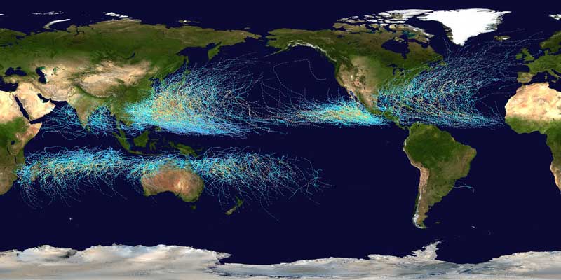
This NASA map image shows the tracks of all Tropical cyclones which formed worldwide from 1985 to 2005. The points show the locations of the storms at six-hourly intervals and use the color scheme from the Saffir-Simpson Hurricane Scale (click to enlarge).